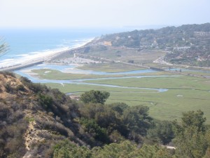
What is Los Penasquitos Lagoon?
Los Penasquitos Lagoon (LPL) is a relatively small estuary located in northern San Diego county where the Los Penasquitos watershed meets the ocean. Three sub-watersheds located within the overarching Los Penasquitos watershed are drained by the Los Penasquitos, Carrol Canyon, and Carmel Valley creeks. Recently, due to the urbanization of the watershed, Carrol Canyon and Carmel Valley creeks, which used to only flow during the winter months are now flowing year round causing a shift in vegetation species (from salt marsh to brackish).
 Historically, the lagoon was known to be open to the sea year-round. However, increased sedimentation from agricultural and grazing practices as well as railroad construction during the 1920s and 30s brought about a pattern of seasonal mouth closure. In the 1960s, the dumping of treated waste from upstream sewage plants led to high levels of nitrate and phosphate content in the water. Algal growth and decomposition levels skyrocketed, resulting in depleted dissolved oxygen levels in the water. During this time, mosquitoes and midges thrived, while most of the other wildlife died off and decomposing matter accumulated at the lagoon mouth.
How are the problems being dealt with?
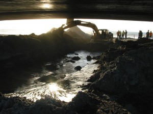
In 1985, California Coastal Conservancy developed an LPL Enhancement Plan to deal with the degradation of the lagoon. The Los Penasquitos Lagoon Foundation was put in charge of management and formulated a plan to monitor the water quality and open the mouth mechanically before water quality became 
What kind of monitoring is done at LPL?
Water quality is measured by a datalogger placed near the lagoon mouth, which takes readings of turbidity, pH, chlorophyll, salinity, temperature, and water depth. Spatial water quality, taken every two weeks, measures water temperature, salinity and dissolved oxygen at different depths of the mouth at three different stations in the lagoon. Flow rates at the different tributaries of LPL are measured monthly. Additionally, vegetation surveys are taken twice a year in the lagoon area to document the transition of vegetation species and habitat due watershed urbanization. When mouth closure occurs, this monitoring data is used for the justification and timing of the mechanical mouth opening so that the lagoon remains a thriving natural habitat.
