FloodRISE
Project overview
The FloodRISE project was funded by a grant from the NSF Hazard-SEES program to research the potential for metric resolution flood hazard simulations to enhance flood risk management. Advances in remote sensing, flood simulation algorithms, and computational power now makes it possible to simulate flooding at fine scales comparable to how people experience flooding, and there is a pressing need for new knowledge about the ways that these simulations can enhance flood risk management (e.g., through mitigation, planning, preparedness, early warming, emergency response, recovery) and thus help communities become less vulnerable to flooding disasters.
Research conducted
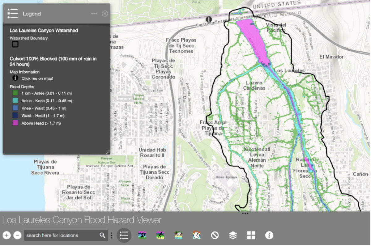
Under FloodRISE, an interdisciplinary research team worked with stakeholders in three communities affected by different types of flooding (e.g., coastal, fluvial, pluvial) to co-develop sets of flood hazard visualizations that are responsive to local decision-making needs. Stakeholder engagement was iterative and involved meetings with authorities, household surveys, focus group meetings and training sessions. The co produced flood hazard maps are available via on-line flood hazard viewers.
FloodRISE – Tijuana River Valley Flood Hazards (arcgis.com)
Water | Free Full-Text | Addressing Pluvial Flash Flooding through Community-Based Collaborative Research in Tijuana, Mexico (mdpi.com)
Findings
Over a period of several years, we developed and refined computer model depictions of flooding and measured the ways in which this process made affected communities more resilient. Our conclusions:
- Collaborative Flood Modeling resulted in high levels of participation among potential end-users of flood hazard information and revealed an eagerness for better information to address flood risks among planning, public works, natural resource managers, and emergency responders.
- Perception and awareness of flooding is enhanced more by fine resolution depth contour maps than the FEMA maps depicting flood hazard zones. Fine resolution depth contour maps were also effective at minimizing differences in flood perception across subgroups.
- Actionable flood hazard information was produced by Collaborative Flood Modeling.
- Collaborative Flood Modeling aligns with the strategic plans of FEMA to support local leadership of Flood Risk Management, creating a process for local stakeholders to contemplate flooding, map risks in ways that align with local decision-making needs, and enhance deliberations over strategies and projects to manage risks.
- Use of technical terminology in Collaborative Flood Modeling, and especially statistical concepts such as confidence levels, was disruptive of productive dialogue and discussion about flooding among end-users.
Outcomes & impact
This project has made significant contributions to the understanding of flooding in the Tijuana River Valley and how tools such as collaborative modeling can be utilized for future decision-making. You can explore the project’s significance further in this scientific article: Collaborative Modeling With Fine‐Resolution Data Enhances Flood Awareness, Minimizes Differences in Flood Perception, and Produces Actionable Flood Maps
Sponsors & supporters